


By TheDailyNewsHub
The United Nations General Assembly has endorsed an African-backed resolution encouraging the use of a world map that represents the relative size of continents more accurately, particularly the size of Africa.
The resolution, sponsored by Togo on behalf of the African Group and supported by the African Union, was adopted on Friday, September 4, with 164 countries voting in favour.
The United States was the only country to vote against the resolution, while six countries—Estonia, Georgia, Lithuania, Moldova, Serbia and Ukraine—abstained.
What is changing?
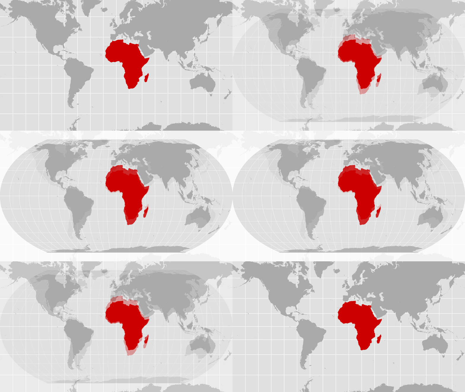
The resolution promotes the use of the Equal Earth projection, an equal-area map designed to represent the relative sizes of landmasses more accurately.
It seeks to encourage governments, schools, international organisations and technology companies to consider Equal Earth and other equal-area projections instead of relying exclusively on the widely used Mercator projection when showing the relative size of continents and countries.
The Mercator projection was developed by Flemish cartographer Gerardus Mercator in 1569, primarily for maritime navigation. While it is useful for navigation because of the way it represents direction, it significantly enlarges areas as they move away from the Equator.
Africa appears much larger on Equal Earth
One of the most striking differences between the two projections concerns Africa.
On conventional Mercator maps, Greenland can appear to be roughly comparable in size to Africa. In reality, Africa is about 14 times larger than Greenland.
Africa covers approximately 30.3 million square kilometres, making it the world’s second-largest continent by land area. The Equal Earth projection depicts this difference much more accurately.
Supporters of the initiative argue that the way maps represent the world can influence how people perceive the importance and scale of different regions.
Togo’s Foreign Minister, Robert Dussey, said before the vote that maps “shape our understanding of the world” and influence education and collective perceptions.
African Union-backed campaign
The initiative emerged from an African-led campaign commonly referred to as “Correct the Map.”
Togo took the proposal to the United Nations on behalf of the African Group, which comprises the 54 African UN member states. The African Union backed the campaign, which seeks greater awareness of the distortions created by commonly used world map projections.
Supporters have argued that the widespread use of Mercator has contributed to a distorted visual understanding of Africa and other regions close to the Equator.
However, cartographers note that every flat map of the Earth involves some form of distortion because the planet is spherical. Equal Earth prioritises the accurate representation of area, but it does not make every geographic feature perfectly accurate in shape, distance or direction.
Why did the US vote against it?
The United States was the sole country to oppose the resolution.
Washington described the initiative as part of what it regarded as an ideological project and argued that the UN should focus on what it considers more pressing international challenges.
The US vote has attracted attention because the resolution received overwhelming support from the rest of the General Assembly.
The Mercator map has not been banned
Despite the dramatic headlines surrounding the vote, the United Nations has not banned the Mercator projection.
The resolution is non-binding and does not require countries, companies or individuals to stop using Mercator maps. Instead, it encourages greater use of Equal Earth and other equal-area projections when accurate comparisons of landmass size are important.
Mercator also remains useful for certain forms of navigation, meaning it is unlikely to disappear completely from maps and navigation systems.
The UN decision therefore represents more than a change in cartographic preference. For its African supporters, it is also an attempt to challenge longstanding perceptions created by the way the world has traditionally been depicted.
For Africa, the message is straightforward: the continent was never as small as many familiar world maps made it appear.
UN backs a new world map showing Africa in its true relative size